
 I love a good map.
Historical maps, world maps, city maps, street maps... it doesn't matter. I just think that maps are cool to look at, and I've accumulated quite a few of them over the years. Mostly from places I've been, but also from places I want to go (like the Aegean) and places I will probably never go (like the planet Mars). I even like these newfangled internet maps like MapQuest and Google Maps. Sometimes I wish I had a GPS so I could see myself on a map wherever I am. Because that's how much I love maps.
My map passion began in a very unlikely place... an album cover.
In 1984 one of my favorite bands of the day, The Thompson Twins, released their latest work titled Into The Gap. In addition to unforgettable 80's musical favorites like Hold Me Now and Doctor! Doctor!, the back of the album cover had a very cool treatment of the Thompson Twins logo by the artist Satori...
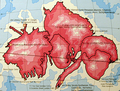
He had turned it into a map! And then he put the album credits as cities on the map!
This fascinated me. I had never thought of maps as art before, but here was an incredibly cool artistic statement that inspired me to take a look at "real" maps. And I was hooked. From that moment onward, I was a cartography whore.
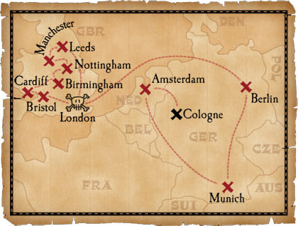
So much so, that I started creating my own maps. Sometimes of real places, like this map of the Hard Rock Cafe run Perry and I took...
Other times I make maps of fake places, or of fake places that should be real. Like the sovereign nation of Davenia...
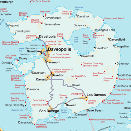
I drew this map back in 1998 for the relauch of "DaveWorld", which never happened (close-ups of the map can be found in an extended entry).
So what's all this leading up to? Glad you asked...
One of the greatest map inventions of the 20th century was the laminated roadmap. And the best of these was "FastMap", which was manufactured by the HM Gousha Company. These fantastic travel companions are always in my car, ready for use at a moment's notice. They are low-profile, single panel height, accordion-style maps that are brilliant both in execution and design. And, because they're laminated, they wear well and don't rip apart like paper maps. Eventually, map giant Rand McNally came out with their own laminated maps, but they were pale imitations that folded out to HUGE dimensions and were difficult to use in a car. The leaner, meaner FastMap was a much better choice.
So can you guess what happened next?
Rand McNally bought out the HM Gousha Company in 1996. This was a smart move, because now Rand McNally could have access to the wonderful FastMap catalog, and release this superior product under the Rand McNally name!
But I think we all know that's not what happened. Rand McNally promptly discontinued FastMaps in favor of their own INCREDIBLY CRAPPY AND PRACTICALLY WORTHLESS PIECE-OF-SHIT laminated maps. This means that my beloved FastMaps, which are now falling apart, cannot be replaced thanks to the dumbass bastards at Rand McNally (whose web site has sections that are not Mac-compatible, by the way).
Needless to say, I am not happy about this. And, to add insult to injury here, I couldn't buy a new Washington State map from Rand McNally even if I wanted to... they're out of stock. Somebody at Rand McNally needs a serious bitch-slapping.
Anyway, more Davenia maps are in an extended entry, if things like that interest you...
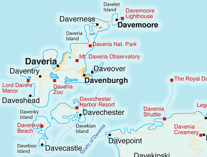
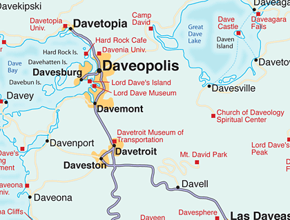
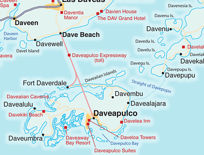
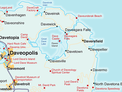
See, told you it should be a real place. I'd rather be in Daveapulco.

I love comments! However, all comments are moderated, and won't appear until approved. Are you an abusive troll with nothing to contribute? Don't bother. Selling something? Don't bother. Spam linking? Don't bother.
PLEASE NOTE: My comment-spam protection requires JavaScript... if you have it turned off or are using a mobile device without JavaScript, commenting won't work. Sorry.

I like that the Hard Rock Cafe and LegoLand both don’t have Dave in their names, presumably because they don’t need Dave in their names – their Dave-ish enough already.
Can I get a job at the Lord Dave Museum? I could be a tour guide… “And on the left are the outfits Dave and Liz wore on their wedding day… Over here is the chance to see the video of the day the Governments of the world voted Dave to be Supreme Ruler… And don’t forget to visit the gift shop!”
Have you ever seen the Dynamaps at UrbanMapping.com?
http://urbanmapping.com/map_popup.html
These are way cool maps that you tilt (like old trading cards with different views) and can see different views of the same area (imagine a Google Map on paper that you can switch between the Road/Satellite/Hybrid views) such as the roads, subways and boroughs…
Unfortunately, I think all they ever made was Manhattan.
So have you e-bayed for a replacement?
Camp David. LMAO
Nice.
Can I ask how you made the Davetopia map? Is there software that helps you generate that, or was it all freehand?
I MUST KNOW.
Ash: I thought Dave Rock Cafe and LegoDaveLand were a little over the top…
Bec: Sure. No need to fill out an application… the fact that you read Blogography proves that you obviously have the intelligence for the job. 🙂
Gary: Now that is just cool. Have you ever seen one in person.
Amamgets: I tried once and found nothing, but that was years ago. I doubt anybody would want to part with their FastMaps though… because they are too cool.
Chanakin: Oh yes. I need a retreat for when the pressures of ruling the world and having people worship me get to be too much.
Pauly: Everything was drawn by hand in Adobe Illustrator. I’m crafty like that. 🙂
I looked and looked but couldn’t find Liz’s palace of Seduction anywhere…
And if I wanted to live in Daveholm – how do I get there?
You bastard, you are drawing maps by hand! (See how you’re always a bastard when I’m jealous of you?) I’m buggin out right now.
I love maps, too. I totally buy those laminated foldup maps whenever I plan a trip somewhere. I get mine at Barnes & Noble, and I think they’re still available (now I’ll have to go double check). The brand they sell is Streetwise Maps.
You could have gone with DavoLegoLand, that would have worked.
I’m imagining the, er, creative scenes that would unfold in the LegoLand of Davenia. Probably large parts of it would be unsuitable for children. Which would be cool, since children tend to annoy Dave…wait–now I’m seeing a whole section in which unruly children and b***h-slapped with Legos by a guy in a Dave suit. Hmmmmm.
I vacationed in Davesville once. It was lovely! But the freaks from the Church of Daveology were all over the place and kept asking me if I wanted to take a personality test. And I kinda suspect the shower in my hotel had hidden cameras.
DaveI Davelike Davemaps Davetoo. DaveMany Davehours Davehave Davebeen Davespent Davelooking Daveat Davemy DaveWorldmap Daveand Daveatlas. DaveI Davealso Davemade Davemaps Davefor Davemy Davenationstates Davenation. Davegoodtimes. 🙂
Patrick: Hey, in Davenia… EVERY PALACE is “Liz’s palace of Seduction”!! Daveholm is on the northern archipelago of Daveden… they have their own airport, but I’d suggest the Ferry out of Davenborg, as it’s quite a lovely ride.
Eve: Streetwise maps are great… but they don’t offer road maps by state or city. I think that they’re mostly for tourists and stuff.
Belinda: Legoland in Davenia is just like the Legoland’s here… except bigger and cooler, and there’s a giant statue of me that’s 400 feet tall and made entirely out of Lego. Obviously, there ARE parts of me which are not suitable for children.
Chase: Uhhhh… those people wanting you to take a “personality test” were not from the Church of Daveology. They were from the Davenia Psychology Corps. The DCP goes after people who forget to kneel before my portrait during my public addresses because, obviously, they’re insane.
Ben: Davelicious!
Mooselet: Davewick is quite beautiful. They have an annual Taco Festival when the leaves turn in Davetober.
Dave, did you ever stop to think that the reason Rand McNally is out of Washington State maps is because of Washington State’s new “say-wa” promo slogan ?
Check out terraserver.microsoft.com Dave. It’s an aerial view of wherever you want.
Dave, In regards to have I seen one of the DynaMaps (see above).
Yes, I thought it was so cool I ordered one as soon as I heard about them (I think it was a while before they came out).
I think I preordered a few of the others (months ago, but nothing on them yet) http://urbanmapping.com/pre_order.htm
And I just noticed they are called Panamap (instead of Dynamap) now.
Harold: I’d have guessed that it was a bunch of out-of-staters trying to find directions to the buffet at the Mill Bay Casino!
Nic: I need to find a way to put TerraServer on my mobile phone so I can always look at myself on a map… even when I’m not at a computer. That would so rule!
Gary: I love the concept, and was going to order one just for fun… but they are completely sold out! The pre-orders don’t look very promising considering that they were supposed to be available in 2005. Oh well. Something to look out for, that’s for sure.
What do you think about Google Earth? It’s the most fun I’ve ever had with a map program. As for personal maps for travel… how long until GPS mapping is as widely available to the masses? The above Google Earth is available on my RAZR if I wanted to pay outragous internet fees. 🙁
You have way too much time on your hands for a guy who claims to be as busy as he says he is.
I live pretty close to Davenport as it is. Never realized it was a tribute to you. Scary.
I *heart* maps!
Dave B. I LOVE GOOGLE MAPS! In fact, my travel map (which is in the tab-bar on every page) is built on Google Maps!
Kevin I drew that map 8 years ago when I had more free time (unlike today!).
Melina: And I *heart* anybody who *hearts* maps!
Just a note: STREETWISE® does publish maps of states: California, Florida, New Jersey, Pennsylvania, Southern New England, Northern New England. We also publish country maps of Italy, France, Spain, Ireland and Great Britain. STREETWISE® was the first to use the accordion-fold laminated format in 1984 (first version actually appeared in 1983, official version trademarked in 1984) and FastMap came out in 1986. As for all of you who said you love maps…you are our reason for being.
Oh yeah… Streetwise Maps are totally sweet (I own a half-dozen of them, including the amazing “Artwise Manhattan”). The only problem is that you don’t make enough of them! I need a Washington State map!
I really wish somebody would step forward and come up with maps to replace the horrible Rand McNally double-fold maps that are too big to be used in a car. At least Streetwise understands what constitutes a comfortable, useable size.
whoa! ur just lyk me, i spend my time creating hand-drawn maps and labelling it with some settlements. Nice job with Davetopia